North Gustaberg/Maps: Difference between revisions
From HorizonXI Wiki
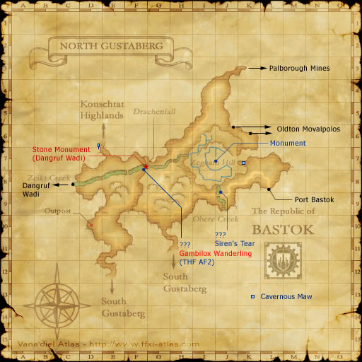
Created page with "<onlyinclude><includeonly> <section begin="Map 1"/>North Gustaberg Map.jpg<section end="Map 1"/> </includeonly></onlyinclude> <imagemap> Image:North Gustaberg Map.jpg| rect 109 139 177 194 Konschtat Highlands rect 349 89 469 104 Palborough Mines rect 365 174 485 193 Oldton Movalpolos rect 375 263 474 290 Port Bastok rect 28 256 103 279 [[Dangruf Wadi/Maps|Dangruf Wadi]..." |
Starfox9507 (talk | contribs) No edit summary |
||
| Line 16: | Line 16: | ||
desc top-left | desc top-left | ||
</imagemap> | </imagemap> | ||
{{overlay | |||
|image = North Gustaberg Map.jpg | |||
|width = 900 | |||
|height = 530 | |||
|legend1title = North Gus | |||
|legend1start = 1 | |||
|overlay1 = test | |||
|overlay1top = 335 | |||
|overlay1left = 25 | |||
}} | |||
Revision as of 14:56, 20 August 2023
 1 | |||||
North Gus
| |||||