Template:FFXIMap Markers
This template defines the table "ffximapmarkers". View table.
Usage
Add this tag to an entity you wish displayed on the FFXIMap. If the map already has the entity listed, then anything added using this template will overwrite what is currently on the map.
{{FFXIMap Markers
|mapid=
|mapx=
|mapy=
|entitytype=
|image=
}}
| parameter | default | type | description |
|---|---|---|---|
| mapid [required] | none | integer | Each zone map has a corresponding id# to help associate markers to map. See table "Map ID Data" at Template:FFXIMap for details on these values. |
| mapx [required] | none | float | The X position for the marker. Please read Coordinate Systems below for details if you are unfamiliar with this. A marker position must be within those bounds to be visible on the map. In order to get these numbers you must view an FFXIMap with the added parameter 'showdetails=true' and use the mouse to determine the coordinates of a specific location. See Template:FFXIMap for more details. |
| mapy [required] | none | float | The Y position for the marker. Please read Coordinate Systems below for details if you are unfamiliar with this. A marker position must be within those bounds to be visible on the map. In order to get these numbers you must view an FFXIMap with the added parameter 'showdetails=true' and use the mouse to determine the coordinates of a specific location. See Template:FFXIMap for more details. |
| entitytype [required] | none | number | There are "types" of markers (ie: NPC, Seasonal NPC, ???, Standard Merchant, etc...). These types are bundled in layers on the FFXIMap where the user is able to turn on/off a particular layer they want to see. |
| image [optional] | none | text | This is the filename of the image. Do not use wikitext in this field. |
Example Usage
This tag is added to the bottom of a page which you want added as a marker to a map.
{{FFXIMap Markers
|mapid=141
|mapx=-4.23
|mapy=49.75
|entitytype=NPC
|image=Guslam.png
}}
Coordinate Systems
General rules of thumb:
- You must know if the map you are adding to is using IN-GAME or BASIC coordinates. This is how you would do that:
<FFXIMap mapID=62 zoom=1 width=800 height=800 showdetails=true/>
- IN-GAME coordinates are based on the coordinates in-game. Simply target an NPC/entity you wish to create a marker for, and use those X and Y values for the mapx and mapy listed below.
- BASIC coordinates are based on a 0-256 pixel grid, where the bottom left of the map is [0,0] and the top right of the map is [256,256]. In order to get these coordinates you need to add the 'showdetails=true' attribute to your instance of FFXIMap. With this set as true you can see the coordinates as you move your mouse on the map, and clicking the map will post those coordinates below the map for you to copy paste.
Background / Context
Before proceeding you must take a second to understand and appreciate the coordinate systems available. In Vana'diel every zone has its own [X,Y, Z] based coordinate system. At the inception of this interactive maps project we did not anticipate using the actual in-game coordinates for any map, because putting markers on the map was never really part of the plan. So from the beginning each map used the same [X,Y] coordinate system, where the bottom left of the map was [0,0] and the top right of the map was [256,256]. Most maps are still on this coordinate system. We have only recently begun to add the actual in-game coordinates to each map, and this is a lengthy process.
When adding markers to the map you must know exactly which coordinate system the zone map is using. You can determine this by editing the
FFXIMap tag and adding the 'showdetails=true' attribute.
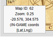
This is an example of what the map will display. In this case, it is Upper Jeuno and this particular map is using the IN-GAME coordinates:

IN-GAME coordinates are based on latitude and longitude, so when you see these coordinates in this info box on the bottom left they will be displayed as [LAT,LNG] which is actually [Y,X]. Hovering over any marker with your mouse will display the coordinates properly as [X,Y].

